Catch up #3 - Sketching Class
The Past two weekend in a row I have caved both Saturday and Sunday. Its been really fun to get back into being out both days. Yesterday I took a sketching class for surveying in Tumbling Rock - in order to draw cave maps. Eleven of us learned/practiced profiles, cross sections and plan views, and in general, sketching to scale and what types of features to draw and put in cave maps. It was really fun and I learned quite a lot. Now all in need is some practice.

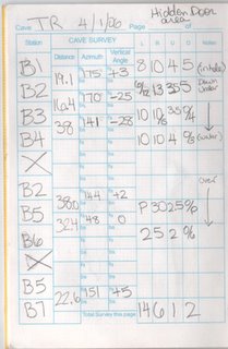
This is the setup for the information that you get from the survey stations. The distance between stations the angle up or down, how many feet to the walls, left and right, how many feet to the floor and ceiling.

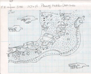
This is my plan sketch for the Hidden Door area of Tumbling Rock on a scale of 1 inch= 20 feet. The two items and the top and one at the bottom are cross section "slices" of the passageway. The dots are the symbol for sand the dashes or hatches are mud. The rocks are breakdown, both large and small. There are some symbols for soda straws near the top and there are "T" shaped ones that mean a change in ceiling height. The triangles are formations - stalagmites & tites.
Labels: caving

1 Comments:
Did you learn all those fine drawing skills from Mrs. Whats-her-name's drawing class at Flagler? Oh, wait, we didn't learn anything in there because we were too busy goofing around with AJ and Joey :)
Gosh, what WAS that woman's name?
Post a Comment
<< Home